|
||||||||||||||||||||||||||
 |
||||||||||||||||||||||||||
|
Lidar Basics What is a Lidar?A lidar (LIght Detection And Ranging) is an instrument that operates by emitting laser light and detecting the light reflected back by objects towards the unit. Lidars harness the fundamental properties of laser light to perform precise detection:
Lidars is similar to RADAR (RAdio Detection And Ranging), but uses laser pulses rather than radio waves. The device can only collect information for objects the same size as the wavelength emitted or larger, but not smaller. Since the laser pulses have wavelengths 105 times smaller than those of radio waves, lidars can detect much “smaller” particles. This fact, in combination with the properties listed above, is what makes lidar particularly helpful when studying the structure and composition of the atmosphere – especially concerning the very tiny aerosols and cloud particles! There are many different types of lidars that may accommodate for a particular type of field study, or that measure a specific atmospheric variable, including particles, clouds, smoke, wind speed, and even the densities of oxygen or nitrogen. This is possible by virtue of the laser’s monochromaticity – by setting this to different wavelengths, different atmospheric properties can be targeted. Of particular interest here is the upward-pointing, elastic backscattering, dual-wavelength lidar system to study atmospheric aerosols. What are aerosols?The term aerosol describes particulate matter and/or liquid droplets suspended in the air. They are generated by both biogenic (natural) and anthropogenic (man-made) processes, and can come from sources as close as our own neighbourhoods, to those far beyond our field of view (such is the case of trans-Pacific transport). The processes that create aerosols include:
It is important to note that increased levels of aerosols can have adverse effects on human health and the environment, and are only one of many types of potential atmospheric pollutants. Aerosols can:
So, studying the quantity and composition of aerosols in the atmosphere is crucial to protect ourselves and our environments – and of course, Lidars can help facilitate this! As you will soon discover, lidars can also help us determine the source of observed aerosols. *Field tip: On hazy days, it may be worthwhile to look up the current air quality conditions. Recall here that increased particulate matter in the atmosphere can greatly reduce visibility. *Field tip: When taking measurements in the field, you may be surrounded by a multitude of aerosol sources, both biogenic and anthropogenic. Take special notice of what these could be, and how they may affect your measurements. How does it work?In the simplest of terms, a lidar works by emitting a laser beam directed upwards into the sky, and capturing the scattered light reflected by particles in the atmosphere into a telescope. The light received by the telescope is known as backscattering (i.e. the light returned backwards along its original trajectory). Of course, not all of the emitted laser light can be scattered directly back towards the lidar system. In fact, three processes may occur:
These processes are illustrated accordingly in the figure below. But we can say that as a general rule, the more aerosols present in the atmosphere, the more backscattering there will be (for more information, see the Interpretation section). 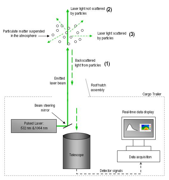
Schematic drawing of lidar setup.
Lidars make measurements by emitting laser pulses several times an hour to reveal the structure of the atmosphere, as aerosols act as tracers for evolving structures. The faster the laser pulses, the better the time-resolution of collected backscatter data. Since the laser is collimated, lidar measurements are made from around ground level up to very large distances (usually 12 – 20 km). It can operate 24 hours a day, all days of the year, except during precipitation events. Keep in mind that lidars emit extremely high radiation, so it must also shut-off when objects fly overhead, such as airplanes, or even birds! 
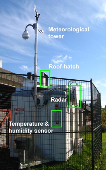
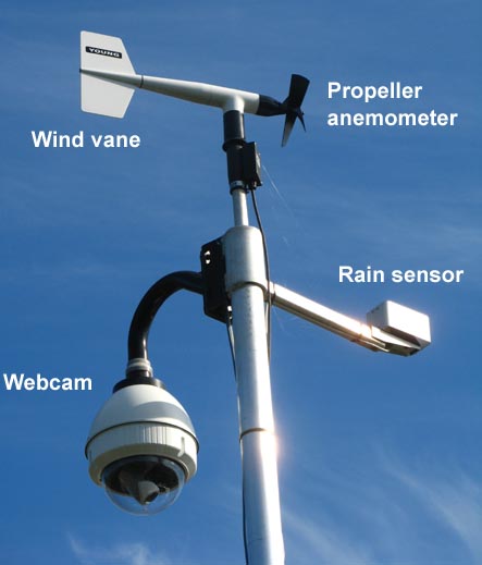
A danger sign on the side of the lidar trailer The whole story: the CORALNet-UBC lidarThe UBC lidar was the first station deployed by CORALNet (Canadian Operational Research Aerosol Lidar Network) on April 16th, 2008. It is located on Totem Field, 100 m north of the UBC Climatology Station, in a modified cargo trailer. The lidar itself is accompanied by a basic meteorological tower, and three webcams to monitor sky conditions and the station’s operational status. A precipitation sensor and radar are used to signal when to shutoff the lidar and close the roof hatch at the top of the trailer – this, of course, causes system downtime and no observations are made in these instances. There is also significant operational downtime due to maintenance and reactivation sequences after shutoff by precipitation. The CORALNet-UBC lidar pulses 10 times every second (10 Hz), and backscatter information is collected at 3 m vertical resolution, up to 15 km above ground. These settings result in data with extremely high temporal and spatial resolution! The laser simultaneously emits two wavelengths (532 and 1064 nm), and measures backscattering at three separate channels: 532 nm polarized and depolarized, and 1064 nm. These signals are then translated to produce real-time output. The system can be remotely operated, and first-look images are updated online every hour for the public on the CORALNet website.
Exterior setup of the CORALNet-UBC lidar station (left), and a close-up of instruments of the basic meteorological tower (above).
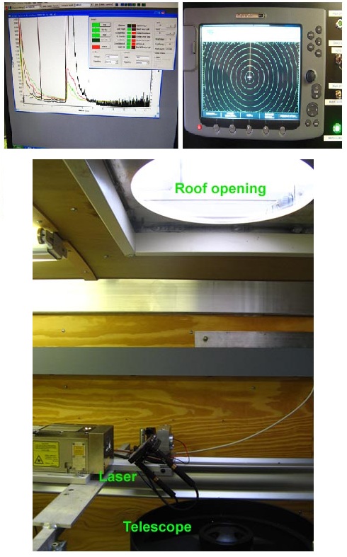
Interior components of the CORALNet-UBC lidar system (left), with a close-up of the radar screen and raw output (top right). From the photo of the laser set up (bottom right), can you match up the instruments to the previous schematic diagram? Why use multiple wavelengths?You may be wondering why the CORALNet-UBC lidar emits two wavelengths (532 and 1064 nm) and receives backscattering information at three channels (532 nm polarized and depolarized, and 1064nm). Why is all of this information necessary? Why not use just one wavelength? As we explained above, using different wavelengths can help scientists target different properties of the atmosphere. We also know that a laser can only measure objects that are the same size or larger than its own wavelength. This means that a 532 nm laser pulse can measure smaller particles than can a 1064 nm laser pulse, which could correspond to entirely different particles in the atmosphere. First, we note that a single emitted wavelength measuring backscatter by aerosols is dependent on the concentration of aerosols present (as a rule of thumb, “the more aerosols, the more backscattering”), which can tell us about the “quantity” and characteristics of the aerosols, such as the index of refraction. Second, we note that the two emitted wavelengths are in different ranges of the electromagnetic spectrum. The 532 nm pulse is in the visible range, and the 1064 nm is in the infrared (IR) range. Both of these wavelengths measure aerosols and clouds, but comparing them can tell us about the size distribution of the aerosols. We should also keep in mind that some wavelengths are inherently more useful than others, depending on what we are interested in observing. For instance, the 1064 nm channel has a higher signal-to-noise ratio. And, the 532 nm penetrates water molecules with much less attenuation than does the 1064 nm. Finally, a lidar emits nearly 100% polarized light, regardless of the wavelength. However, the return signal may be significantly depolarized, as we discussed in the previous section. In fact, this depends on the shape of the aerosols responsible for the observed backscattering. So, using a depolarized channel can help us decipher the type – and eventually, the source – of the aerosols. For further explanation of using the three channels of lidar output, please read the Interpretation section. Summary
Continue to the Utility of Lidars >>
|
|
|
Department of Geography - Faculty of Arts - The University of British Columbia | |||||||||||||||||||||||