
What is GIS?
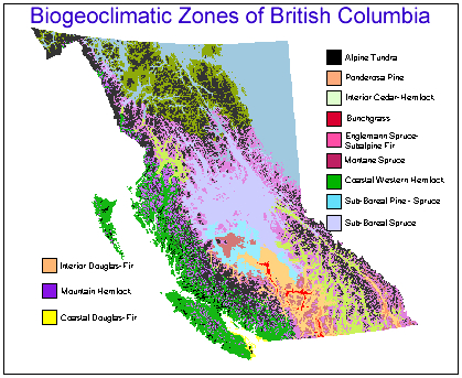
This map layer displays the biogeoclimatic zones of British Columbia
GIS is a broadly used term that can mean different things to different people. To some, it is merely a tool used for data analysis, and comprises using software to produce maps and do statistical analyses. To others, GIS means Geographical Information Science, that is, the science that lies behind the technology (Goodchild, 1997).
GIS, the tool, is defined as "A computer system for capturing, storing, checking, integrating, manipulating, analysing and displaying data related to positions on the Earth's surface. Typically, a Geographical Information System (or Spatial Information System) is used for handling maps of one kind or another. These might be represented as several different layers where each layer holds data about a particular kind of feature. Each feature is linked to a position on the graphical image of a map. Layers of data are organised to be studied and to perform statistical analysis." (University of Edinburgh and Association for Geographic Information, 1996).
Geographical Information Science (or GIScience) is defined as "studying the theory and concepts that lie behind GIS and the other geographic information technologies" (Goodchild 1997). It encompasses "geodesy, cartography and photogrammetry...and should extend to include areas like cognitive psychology and spatial statistics" Goodchild 1997).
A detailed write up on "what is GIS" is available.
In E-Fauna BC and E-Flora BC, we work with interactive GIS mapping in order to produce distribution and biogeographic mapping. Using Arc-IMS software, one of the GIS technologies, we can produce base maps and map layers that can be viewed separately or as overlays in order to either view species distributions, or assess the biogeoclimatic patterns and influences that lie behind the distributions.
However, our work is informed by GIScience. Understanding the theoretical underpinnings of GIS and mapmaking allows us to develop mapping that best illustrates the biodiversity of the province.
References:
Goodchild, Michael F. 1997. What is Geographic Information Science? NCGIA Core Curriculm, Unit 002. In: NCGIA Core Curriculum in GIScience. University of California, Santa Barbara.
University of Edinburgh Department of Geography and the Association for Geographic Information. 1996. The GIS Dictionary. Santa Barbara. Web site accessed February 28th, 2004. http://www.geo.ed.ac.uk/agidict/welcome.html)
Recommended citation: Author, date, page title. In: Klinkenberg, Brian. (Editor) 2021. E-Flora BC: Electronic Atlas of the Flora of British Columbia [eflora.bc.ca]. Lab for Advanced Spatial Analysis, Department of Geography, University of British Columbia, Vancouver. [Date Accessed]
E-Flora BC: An initiative of the Spatial Data Lab, Department of Geography UBC, and the UBC Herbarium.
© Copyright 2021 E-Flora BC.