BIOGEOCLIMATIC ECOSYSTEM CLASSIFICATION DATABASE
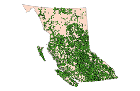
The BEC database consists of 48,225 stations distributed about the province of BC (see the map below). There are 727,852 records associated with the 5789 taxonomic entities (i.e., species, subspecies, varieties and forms) found at the 48,225 stations. Descriptions of the field data collected at each station are presented on the Ministry of Forest web pages-- Field Manual for Describing Terrestrial Ecosystems.

The distribution of the BEC field stations.
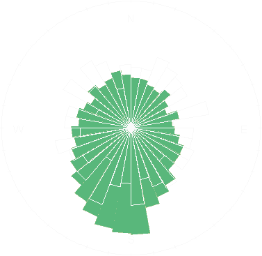
Using the BEC database we can determine, for example, what the range of aspects are for the 20,000+ stations (the bars with the white outlines shown in the figure below), and for the 2231 species identified in the database (the green bars in the figure below). The differences between the two rose diagrams (circular histograms that display directional data like aspect) indicate that more species are found on south-facing slopes than on slopes facing east, north and west.

Summaries of the BEC variables will be included on the Atlas sheet for a species if that species occurs within the BEC database.
Recommended citation: Author, date, page title. In: Klinkenberg, Brian. (Editor) 2021. E-Flora BC: Electronic Atlas of the Flora of British Columbia [eflora.bc.ca]. Lab for Advanced Spatial Analysis, Department of Geography, University of British Columbia, Vancouver. [Date Accessed]
E-Flora BC: An initiative of the Spatial Data Lab, Department of Geography UBC, and the UBC Herbarium.
© Copyright 2021 E-Flora BC.