Fraser River Gravel Reach
Studies
UBC Department of Geography
UBC Department of Geography
|
|
Fraser River Gravel Reach
Studies
UBC Department of Geography |
|
|
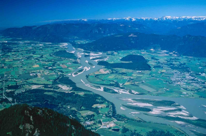 Between Laidlaw and Sumas Mountain (see figure), the riverbed of Fraser River is rising slowly because gravel that the river transports out of the mountains is deposited there. The rising channel bed in turn increases water levels and threatens the channel banks. These effects reduce the security against flooding provided by the dykes. There are several ways to tackle the problem that this presents. Removing gravel from the river might appear to be an obvious one. But . . . the reach has an exceptionally diverse aquatic ecosystem with high economic value. Nearly 30 species of fish are found here, including ten salmonids. The recreational opportunities of the river are increasingly recognised, and there are growing concerns to maintain ecosystems and biodiversity in our landscape. Experience elsewhere has taught us that when large volumes of gravel are mined from rivers, the river changes dramatically and, with it, the river ecosystem. Our problem, then, is to find a way to manage the river to maintain or improve the existing flood protection while maintaining the ecological character of the river. Questions to be answered include the following:
|
| Prof. Michael Church UBC mchurch@geog.ubc.ca (604) 822-6959 | Darren Ham Ph.D. candidate fraser@geog.ubc.ca |