
Window Seats
Los Angeles, March 2008
CopyLeft 2008 Elvin K. Wyly
Except where otherwise noted, this site is
licensed under a Creative Commons Attribution 2.5 License
"A snapshot is a permanent record of a time and place. A geographical snapshot captures some essence of that record through the eyes and scholarly analysis of a geographer. In its elemental form, the geography of a region is an amalgam of points and lines that define its landscape features. Some points and lines are visible and easily spotted from the window of an aircraft or from an earth-bound vehicle. Some are but fleeting events that leave no permanent mark; while others, although abstract, underlie our geography. Geographers interpret these landscapes from a variety of theoretical and applied viewpoints and with a varied set of remarkable tools. They include maps, remotely sensed images, photographs, sketches, graphical analysis, mathematics, and literary skill." Donald G. Janelle, ed (1992). Geographical Snapshots of North America. New York: Guiford Press, quote from Introduction, p. 1.
"The apex of twentieth-century modernist urban planning in Los Angeles is perhaps best represented by the freeway-building era. Transit-rationality was replaced by a freeway-rationality .... The freeways ultimately created the signature landscape of modernist Los Angeles -- a flat totalization, uniting a fragmented mosaic of polarized neighborhoods segregated by race, ethnicity, and class." And as the challenges come "from those left behind and unable or unwilling to unroot themselves to the new frontier" we see " clear nonconformity between Los Angeles' persistently modernist urban planning and the emergent postmodern urbanism of Southern California." 'The' becomes redefined through plurality, contradiction, contingency, and perhaps a bit of chaos. "There is no longer a single civic will nor a clear collective intentionality behind LA's urbanism; and the obsolete land-use planning machinery is powerless to influence the city's burgeoning social heterodoxy. This is the insistent message of postmodern Los Angeles: that all urban place-making bets are off; we are engaged, knowing or otherwise, in the search for new ways of creating cities." Michael J. Dear (2000). The Postmodern Urban Condition. Oxford: Blackwell, quotes from p. 110, 111.


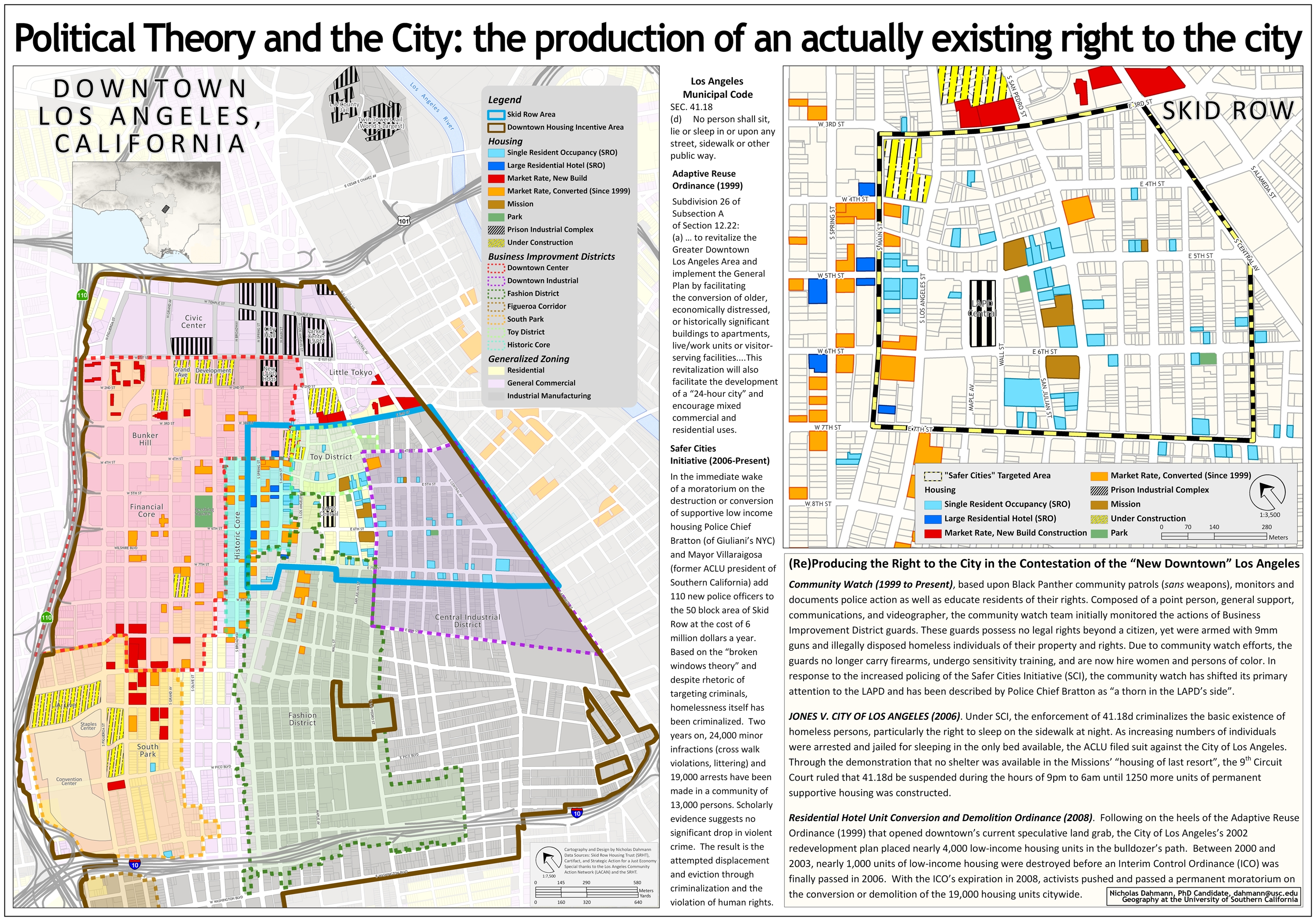
Copyright © 2008 Nicholas Dahmann; posted here with permission.
Aerial views like those shown above present a very serious risk of distanciated distortion -- privileging geometry, symmetry, and perspective at the expense of the processes shaping the environments that wind up distilled into the image. "The lens removes reality from reality better than a surgeon, and allows us to witness killing with impunity, nakedness without shame, weddings without weeping, miracles without astonishment, poverty without pain, death without anxiety. It discovers a desirable titillation in overlooked, humble, ugly, out-of-the-way or unlikely objects, often reflecting the interest of a social class in what the camera considers exotic." [William H. Gass (1977). "A Different Kind of Art." Review of Susan Sontag, On Photography. New York Times, December 18.] And yet if we regard the view from the window seat not as the answer, but as the preliminary question that begins the conversation, we can move beyond some of the dangers of a simplistict visual epistemology. Consider, for a moment, the views of downtown Los Angeles as they scroll by above. And then consider the critical cartography, below, of Nicholas Dahmann, who diagnoses the inequalities of class, property, race, and ethnicity that structure the rules and rights of space and place in the urban core.